![Item #108439 A New General Atlas of the World, compiled from the Latest Authorities both English & Foreign, containing Separate Maps of its Various Countries and States, and exhibiting their Boundaries & Divisions, also the Chains of Mountains, Rivers, Lakes and other Geographical Features, comprehended in Forty Sevn [sic] Maps, including Ancient Maps of Greece, the Roman and Persian Empires & Palestine, from Drawings made expressly for this Work by John Dower. Atlas, John DOWER.](https://treloars.cdn.bibliopolis.com/pictures/108439_01.jpg?width=768&height=1000&fit=bounds&auto=webp&v=1536731985)
![A New General Atlas of the World, compiled from the Latest Authorities both English & Foreign, containing Separate Maps of its Various Countries and States, and exhibiting their Boundaries & Divisions, also the Chains of Mountains, Rivers, Lakes and other Geographical Features, comprehended in Forty Sevn [sic] Maps, including Ancient Maps of Greece, the Roman and Persian Empires & Palestine, from Drawings made expressly for this Work by John Dower](https://treloars.cdn.bibliopolis.com/pictures/108439_02.jpg?auto=webp&v=1536734912)
![A New General Atlas of the World, compiled from the Latest Authorities both English & Foreign, containing Separate Maps of its Various Countries and States, and exhibiting their Boundaries & Divisions, also the Chains of Mountains, Rivers, Lakes and other Geographical Features, comprehended in Forty Sevn [sic] Maps, including Ancient Maps of Greece, the Roman and Persian Empires & Palestine, from Drawings made expressly for this Work by John Dower](https://treloars.cdn.bibliopolis.com/pictures/108439_03.jpg?auto=webp&v=1536742555)
![A New General Atlas of the World, compiled from the Latest Authorities both English & Foreign, containing Separate Maps of its Various Countries and States, and exhibiting their Boundaries & Divisions, also the Chains of Mountains, Rivers, Lakes and other Geographical Features, comprehended in Forty Sevn [sic] Maps, including Ancient Maps of Greece, the Roman and Persian Empires & Palestine, from Drawings made expressly for this Work by John Dower](https://treloars.cdn.bibliopolis.com/pictures/108439_04.jpg?auto=webp&v=1536739164)
![A New General Atlas of the World, compiled from the Latest Authorities both English & Foreign, containing Separate Maps of its Various Countries and States, and exhibiting their Boundaries & Divisions, also the Chains of Mountains, Rivers, Lakes and other Geographical Features, comprehended in Forty Sevn [sic] Maps, including Ancient Maps of Greece, the Roman and Persian Empires & Palestine, from Drawings made expressly for this Work by John Dower](https://treloars.cdn.bibliopolis.com/pictures/108439_05.jpg?auto=webp&v=1536737866)
![A New General Atlas of the World, compiled from the Latest Authorities both English & Foreign, containing Separate Maps of its Various Countries and States, and exhibiting their Boundaries & Divisions, also the Chains of Mountains, Rivers, Lakes and other Geographical Features, comprehended in Forty Sevn [sic] Maps, including Ancient Maps of Greece, the Roman and Persian Empires & Palestine, from Drawings made expressly for this Work by John Dower](https://treloars.cdn.bibliopolis.com/pictures/108439_06.jpg?auto=webp&v=1536741391)
![A New General Atlas of the World, compiled from the Latest Authorities both English & Foreign, containing Separate Maps of its Various Countries and States, and exhibiting their Boundaries & Divisions, also the Chains of Mountains, Rivers, Lakes and other Geographical Features, comprehended in Forty Sevn [sic] Maps, including Ancient Maps of Greece, the Roman and Persian Empires & Palestine, from Drawings made expressly for this Work by John Dower](https://treloars.cdn.bibliopolis.com/pictures/108439_07.jpg?auto=webp&v=1536737185)
![A New General Atlas of the World, compiled from the Latest Authorities both English & Foreign, containing Separate Maps of its Various Countries and States, and exhibiting their Boundaries & Divisions, also the Chains of Mountains, Rivers, Lakes and other Geographical Features, comprehended in Forty Sevn [sic] Maps, including Ancient Maps of Greece, the Roman and Persian Empires & Palestine, from Drawings made expressly for this Work by John Dower](https://treloars.cdn.bibliopolis.com/pictures/108439_08.jpg?auto=webp&v=1536739881)
![A New General Atlas of the World, compiled from the Latest Authorities both English & Foreign, containing Separate Maps of its Various Countries and States, and exhibiting their Boundaries & Divisions, also the Chains of Mountains, Rivers, Lakes and other Geographical Features, comprehended in Forty Sevn [sic] Maps, including Ancient Maps of Greece, the Roman and Persian Empires & Palestine, from Drawings made expressly for this Work by John Dower](https://treloars.cdn.bibliopolis.com/pictures/108439_09.jpg?auto=webp&v=1536732838)
![A New General Atlas of the World, compiled from the Latest Authorities both English & Foreign, containing Separate Maps of its Various Countries and States, and exhibiting their Boundaries & Divisions, also the Chains of Mountains, Rivers, Lakes and other Geographical Features, comprehended in Forty Sevn [sic] Maps, including Ancient Maps of Greece, the Roman and Persian Empires & Palestine, from Drawings made expressly for this Work by John Dower](https://treloars.cdn.bibliopolis.com/pictures/108439_10.jpg?auto=webp&v=1536736122)
![A New General Atlas of the World, compiled from the Latest Authorities both English & Foreign, containing Separate Maps of its Various Countries and States, and exhibiting their Boundaries & Divisions, also the Chains of Mountains, Rivers, Lakes and other Geographical Features, comprehended in Forty Sevn [sic] Maps, including Ancient Maps of Greece, the Roman and Persian Empires & Palestine, from Drawings made expressly for this Work by John Dower](https://treloars.cdn.bibliopolis.com/pictures/108439_11.jpg?auto=webp&v=1536743336)
![A New General Atlas of the World, compiled from the Latest Authorities both English & Foreign, containing Separate Maps of its Various Countries and States, and exhibiting their Boundaries & Divisions, also the Chains of Mountains, Rivers, Lakes and other Geographical Features, comprehended in Forty Sevn [sic] Maps, including Ancient Maps of Greece, the Roman and Persian Empires & Palestine, from Drawings made expressly for this Work by John Dower](https://treloars.cdn.bibliopolis.com/pictures/108439_12.jpg?auto=webp&v=1536732733)
![A New General Atlas of the World, compiled from the Latest Authorities both English & Foreign, containing Separate Maps of its Various Countries and States, and exhibiting their Boundaries & Divisions, also the Chains of Mountains, Rivers, Lakes and other Geographical Features, comprehended in Forty Sevn [sic] Maps, including Ancient Maps of Greece, the Roman and Persian Empires & Palestine, from Drawings made expressly for this Work by John Dower](https://treloars.cdn.bibliopolis.com/pictures/108439_13.jpg?auto=webp&v=1536737392)
![A New General Atlas of the World, compiled from the Latest Authorities both English & Foreign, containing Separate Maps of its Various Countries and States, and exhibiting their Boundaries & Divisions, also the Chains of Mountains, Rivers, Lakes and other Geographical Features, comprehended in Forty Sevn [sic] Maps, including Ancient Maps of Greece, the Roman and Persian Empires & Palestine, from Drawings made expressly for this Work by John Dower](https://treloars.cdn.bibliopolis.com/pictures/108439_14.jpg?auto=webp&v=1536735692)
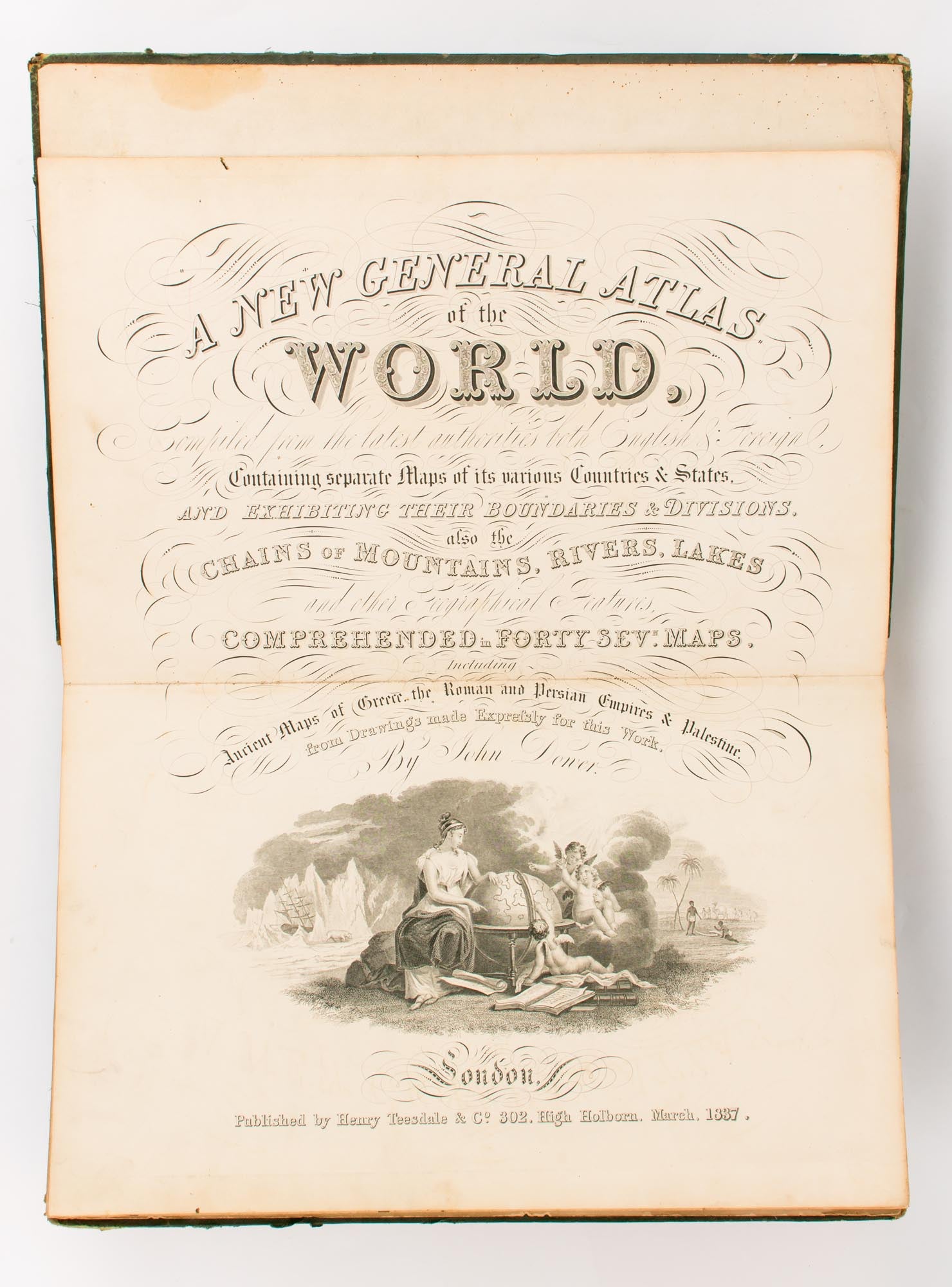
A New General Atlas of the World, compiled from the Latest Authorities both English & Foreign, containing Separate Maps of its Various Countries and States, and exhibiting their Boundaries & Divisions, also the Chains of Mountains, Rivers, Lakes and other Geographical Features, comprehended in Forty Sevn [sic] Maps, including Ancient Maps of Greece, the Roman and Persian Empires & Palestine, from Drawings made expressly for this Work by John Dower
London, Henry Teesdale & Co., March 1837.
Folio, comprising a double-page engraved title with a large vignette, a double-page contents leaf, 44 double-page steel-engraved maps hand-coloured in outline (numbered 1-25 and 28-46), a large folding map of India (numbered 26-27 on the contents leaf, but in fact printed from a single large plate), and a plate showing 'A Comparative View of the Heights of the Principal Mountains and Lengths of the Principal Rivers in the World' (noting also the 'Height reached by Guy Lusach [sic] 22,900' in his hot-air balloon ascent of 1804). All leaves are printed one side only; all but the two hemisphere maps (numbers 1 and 2, which carry only the Teesdale imprint) are 'Drawn & Engraved by J. Dower, Pentonville, London'.
Original half green roan and watered cloth; spine gilt in compartments, with the gilt-lettered spine-title 'Teesdale's General Atlas' (and with the binder's ticket of J. Martin & Sons on the front pastedown); covers a little marked and somewhat worn at the extremities, with trifling loss to the leather; large map of India reinforced with linen at the folds and trimmed close to the printed border; a few short tears expertly sealed; occasional very light foxing and soiling; binding blemishes notwithstanding, a very good copy overall.
The map of 'Mexico and Guatimala' [sic] does not recognise the recently-declared Republic of Texas, but rather continues to show it as a province of Mexico, most likely due to Britain's friendly relations with Mexico. The map of the 'Colony of New South Wales' already shows the 'New Settlement of South Australia' (here in a state unknown to Tooley). The map of 'Van-Diemans Land' [sic] shows 37 districts. The first edition of this atlas appeared in 1831.
Item #108439
Sold