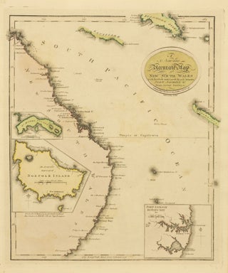
A New and Accurate Map of New South Wales with Norfolk and Lord Howe's Islands, Port Jackson &c. from Actual Surveys
Edinburgh, Thomas Brown, [circa 1807/ 1801]. A map of the east coast of Australia, with inset maps of Port Jackson and Botany Bay, Norfolk Island, and Lord Howe Island. Tooley 21, suggesting Brown's 'A General Atlas' as the source and the date of 1801. This example is from a later..... More