![Item #126825 A mammoth wall map of the settled portions of South Australia, excluding the Northern Territory [circa 1884]. Map: South Australia.](https://treloars.cdn.bibliopolis.com/pictures/126825_01.jpg?width=768&height=1000&fit=bounds&auto=webp&v=1637110555)
![A mammoth wall map of the settled portions of South Australia, excluding the Northern Territory [circa 1884]](https://treloars.cdn.bibliopolis.com/pictures/126825_02.jpg?auto=webp&v=1637110555)
![A mammoth wall map of the settled portions of South Australia, excluding the Northern Territory [circa 1884]](https://treloars.cdn.bibliopolis.com/pictures/126825_03.jpg?auto=webp&v=1637110555)
![A mammoth wall map of the settled portions of South Australia, excluding the Northern Territory [circa 1884]](https://treloars.cdn.bibliopolis.com/pictures/126825_04.jpg?auto=webp&v=1637110555)
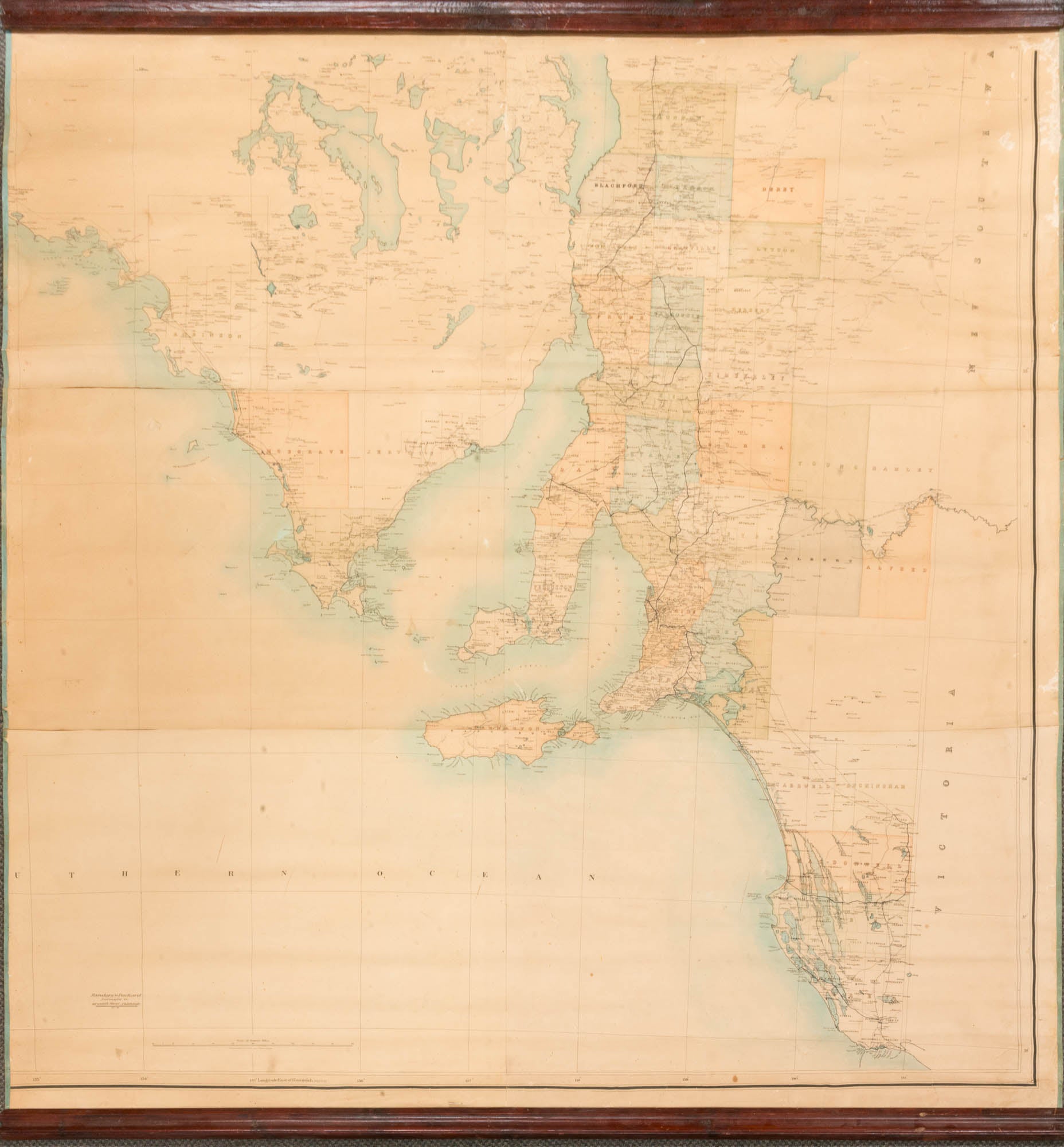
A mammoth wall map of the settled portions of South Australia, excluding the Northern Territory [circa 1884]
Adelaide, Sanders & Packard, Surveyors &c., Grenfell Street, 16 January 1886 (based on maps produced by the 'Surveyor-General's Office, Fraser S. Crawford, Photo-lithographer').
An extensively hand-coloured map printed on paper mounted on linen (overall dimensions 1740 × 1670 mm), formed from six sheets of approximately equal size (visible surfaces range from 534 × 794 mm to 602 × 877 mm).
Outside edges hemmed with silk; contemporary polished and moulded wooden supports lightly attached top and bottom (obscuring about 18 mm of margin each end); minor signs of use and age (there are a few trifling surface blemishes and tiny areas where the paper has separated from the linen backing); essentially, in excellent condition.
A map of the utmost rarity: we have found no record of any other example, and it may well be unique. Charles James Sanders (1846-1923) joined the SA Survey Department 'as a junior draftsman in January 1862, and served as assistant to George Goyder in 1865 and 1866. In 1867 he was engaged in drainage works in the South East, and railway feasibility studies. In 1868 he was appointed draftsman for the Central Road Board, and in 1870 was made Chief Registrar of the Land Office, a post he retained until 1882, when he retired and went into partnership with John Harrison Packard [1847-1929], a member of Goyder's expedition to Darwin, 1869' (Wikipedia). Comparisons may be made between the sheets from which this map is constructed, and the plates in the two superb (and rare) atlases produced by the Survey Department in Adelaide, under the direction of Surveyor-General George Goyder, in 1877-78 and 1885. Differences in the details between these three items lead us to suggest the date 1884 for the map. Two examples should suffice: the County of Carnarvon (Kangaroo Island) contains four Hundreds, including Haines and Cassini, proclaimed in 1883 and 1884 respectively; and the railway line now extending to Nairne was opened on 28 November 1883. The map is not merely a mounted version of plates of the same regions taken from either atlas. It is far more detailed than the first atlas, which also has very distinctive double-page three-colour lithographed maps. It is far more topographical than the second atlas, which does however contain much valuable data relating to land holdings. All of the extensive (and attractive) colouring is by hand, with the railway lines, both completed and proposed, inked in afterwards. The Sanders & Packard details are added by hand in India ink; one distinct possibility is that this map was prepared in-house, with its excellent condition suggesting it was more for decorative than utilitarian purposes.
Item #126825
Sold